

Back In Time -Westfield |
Enter Subtitle |
Will YOU HELP US TO GROW? PLEASE SUBSCRIBE! IT'S FREE! |
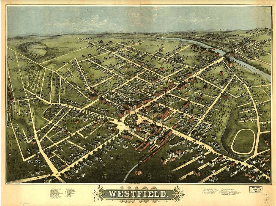
This charming bird's-eye view map from 1875 offers a delightful glimpse into what Westfield, Massachusetts looked like during its transformation from a quiet agricultural community into a bustling manufacturing hub.
Published by O.H. Bailey & Co. (a prolific creator of these panoramic perspectives in the late 19th century), the hand-colored lithograph captures the town from an elevated vantage point, showing a neat grid of streets lined with homes, businesses, churches, and factories. The Westfield River winds through the scene, with bridges connecting neighborhoods, while clusters of trees and open fields remind us how much green space still surrounded the growing settlement.
In 1875, Westfield's population hovered around 7,000 (up from about 6,500 in the 1870 census), and the map vividly illustrates the era's key features: orderly residential blocks, prominent brick buildings (likely homes of merchants and factory owners), and even a racetrack at the edge of town near Main and Meadow Streets—a nod to local leisure and horse-racing culture. The map labels points of interest, highlighting civic buildings, mills, and factories that powered the local economy. Westfield was already earning its nickname as "Whip City" by this time, with the buggy whip industry leading the way alongside cigars, bricks, and emerging metal and textile works. The river provided power and transportation, helping turn the former farming village—settled in the 1660s and incorporated in 1669—into an industrial player in the Pioneer Valley.
These panoramic "bird's-eye" maps were popular marketing pieces in the Victorian era, meant to showcase a town's progress and prosperity to residents and outsiders alike. Looking at this one today, it's striking how recognizable the street layout remains in modern Westfield, even as skyscrapers are absent and the landscape has filled in. A perfect piece of local history—whether you're a longtime resident tracing old family addresses or just someone who loves a good vintage view of the 413.
What stands out to you on the map? |


0 Comments
Join the conversation
Be the first to comment
Share your thoughts above.